Find out more about how the Sealand of today came about.
A History of Sealand — the community that rose from the sea.
Geological / Glacial History
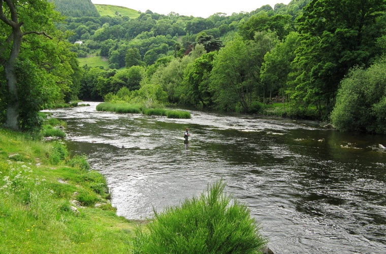
The River Dee estuary is unusual in that comparatively little water occupies so large a basin. One theory is that larger rivers such as the Severn and the Mersey once flowed into the Dee. The current view is that the estuary owes its origin to the passage of glacial ice pushing south- eastwards from the Irish Sea during successive ice ages; eroding a broad and shallow iceway through the relatively soft Triassic sandstones and Coal Measures mudstones which underlie the area. The inner parts of the estuary, including Sealand were filled by glacially derived sands and gravels long ago and infilling by mud and silt has continued since. For a period, the Mersey may also have flowed into the Dee through Sealand by means of a channel which it cut through the base of the Wirral Peninsula, running through the Backford dip and near to what is now Blacon Point.
Original Course of the River Dee
Moving forward through time after the end of the last glacial period, the area that is now Sealand was the eastern section of the River Dee estuary consisting either of flowing water at high tide and mud flats at low tide. The low tide route of the River Dee ran from the Irish Sea to Chester along the bank below Parkgate, Burton, Shotwick and Blacon. This channel was prone to silting so that ships trying to get to the then port of Chester often ran aground because of the lack of water depth. Interestingly the centre of this channel was used to determine the boundary between England and Wales from Blacon Point to beyond Burton. That is why you will now find the three Wales / England boundary signs, on the A548 Sealand Road near to its junction with Western Avenue; on Seahill Road as you drop down the hill leaving Saughall; and on the main roads at the Shotwick interchange. A traveller passing this way before 1735 would have found himself in the middle of the original river course. Read about the River Dee tidal bore.
Building of the New River Channel
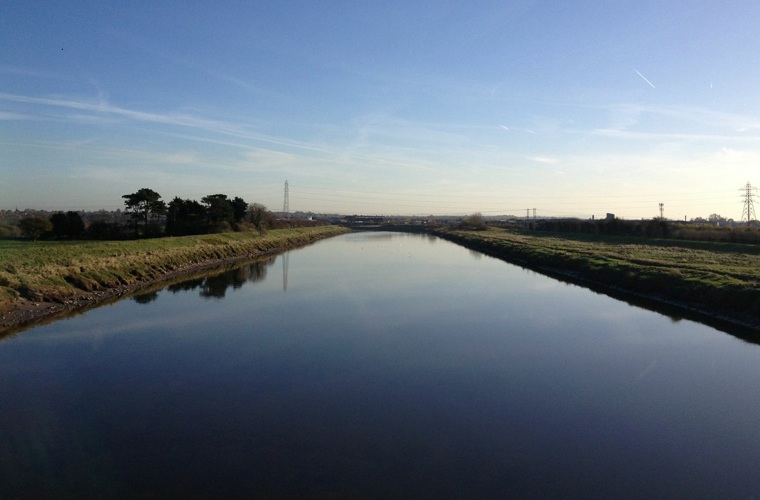
Proposals to build a new channel, date as far back as 1485. Even the Romans experienced difficulties and looked to Neston and Meols, on the Wirral, to off load cargo into smaller boats to get to Chester. Further proposals were made in1684 and then in 1732 John Markay wrote a report stating that unless something positive was done, ships would soon be unable to get to Chester. We can thank a man by the name of Nathaniel Kinderley for the existence of Sealand. His plan was simply to dig a straight new channel from Chester out to Flint on the southern side of the river course, well away from the northern route described above. The proposal was to provide a maximum depth of sixteen feet at a moderate tide. The earth that was removed in digging the channel was to be used for banking on either side of the new channel. The new channel would be over 5 miles long, stretching from Crane Street, Chester to Golftyn, Connah's Quay.
The work was planned and undertaken by engineers from the Netherlands and paid for by local merchants and Chester Corporation. Chester's trade had declined steadily since the end of the 17th century as sediment had prevented larger craft reaching the city. Work was completed in 1737.
The task of reclaiming the land to the east of the canal was done by slowly pushing the sea back up the estuary and building banks from the new cut to the Chester side to reclaim the new land. These banks are known as polders and can be found at various locations across Sealand.
The key dates for the building of the channel and the reclamation of land that is now Sealand are: -
1732: Nathaniel Kinderley proposed the scheme.
1735-1736: Nathaniel Kinderley & Company cut the new Dee channel from Chester to Golftyn at Connah's Quay.
1737: The new Dee channel was opened for shipping.
1740: Kinderley's company became known as the River Dee Company.
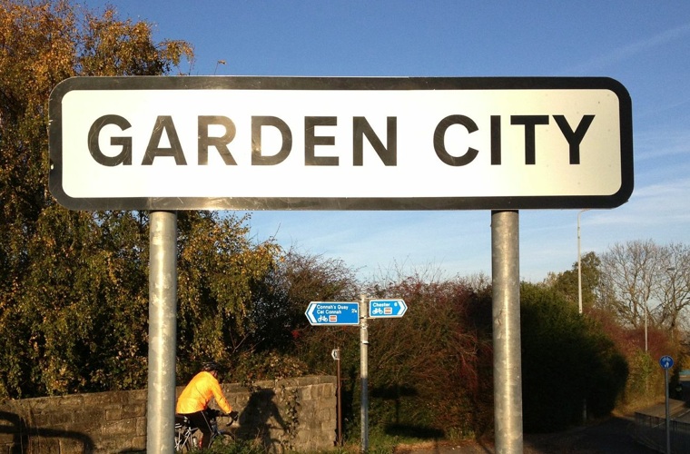
1753: First polder made: enabled the land to the east of it to be claimed from the River Dee, where you will now find the Shooting School, Sealand Manor and Garden City. A polder is a low-lying tract of land enclosed by embankments (barriers) known as dikes, that forms an artificial hydrological entity, meaning it has no connection with outside water other than through manually operated devices
1754: Polder made: Ferry Lane Industrial Estate, Thornleigh Park, Sealand Nursery and Deeside House.
1768: Polder made: Bank Farm and Birchenfields Farm.
1790: Polder made: Yewtree Farm, Church Farm, Sealand village, Waterloo Farm and Willow Farm.
1826: Polder made: Old Marsh Farm, rest of low land east of where the A550 road is now.
1857: Polder made: where the Deeside Industrial Park is now. (In the 20th century this area was raised 2.5 meters / 8 feet by sand pumping.)
1861: The thousands of acres of reclaimed marshlands around Sealand and Saltney were raising £8000 in annual rent.
1865-1867: St Bartholomew's Church, Sealand was built.
About 1880: West of the Dee, a polder including Beeches Farm (a little north of Hawarden Airport) was made.
1892: Polder made: provided the site for Shotton steelworks
The New Area of Sealand
During the 19th century farms and farm dwellings were built in Sealand. St. Bartholomew's church was started in 1865 and completed in 1867. It was built with Helsby stone by Robert Bellis on land obtained from the River Dee Company. The original Sealand Road was built from Chester to Shotwick. In about 1834/35 its course was diverted to its current route from its junction with Seahill Road to what is locally referred to as Drome Corner. The reason for this was to join the new turnpike road which opened in 1833 running from the Wirral to the river ferry at Queensferry. This road is now the A550. The A5117 that joins the A550 at Shotwick was built in the 1930s.
In 1889 the opening of the Hawarden Railway Bridge over the River Dee improved access to the reclaimed Dee Marshes. Following this, in 1895, the Summers family purchased 40 acres (160,000 m2) of Dee marshland on which they established Shotton Steelworks.
John Summers Steel Works
The founder, John Summers, was born in Bolton, Lancashire in 1822. While working as a clogger, he visited the Great Exhibition in 1851, where he bought a nail making machine, and commenced making nails with which to fasten the iron strips on to the soles of clogs. In 1852, Summers moved into Sandy Bank Iron Forge at Stalybridge, where he successfully concentrated on the production of clog irons and nails. He then purchased land near the forge, and built a new ironworks, known as the Globe Works.
John Summers died on 10 April 1876, at the age of 54. Three of his sons, James, John and Alfred, carried on the business, and they were joined by another brother, Henry Hall Summers in 1869. Space for expansion at the Globe Works having been exhausted, the firm opened the Hawarden Bridge Steelworks at Shotton in 1896.
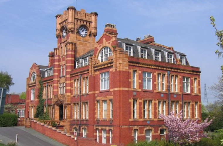
In 1898 the firm became a Private Limited Company and in 1908, on completion of new offices, which are in Sealand , the headquarters were transferred to Deeside. By 1909 the company was the largest manufacturer of galvanized steel in the country, and probably the largest manufacturer of steel nail strips and sheets.
In 1919 the Wolverhampton Corrugated Iron Company at Ellesmere Port was taken over. John Summers & Sons also bought the Castle Fire Brick company in Buckley and the next year took over the Shelton Iron, Steel & Coal Co, Stoke-on-Trent. This company was Shotton's supplier of pig iron, a very scarce item at the time and this acquisition meant that the company had become very largely self-contained and self-sufficient.
John Summers & Sons Ltd was nationalised in 1951, becoming part of the Iron and Steel Corporation of Great Britain. It was then denationalised shortly afterwards, and renationalised in 1967, when the company was absorbed into British Steel. British Steel became Corus in 1999 and this company was taken over by Tata Steel in 2007.
The development of this steelworks on the banks of the River Dee changed an area that was once mainly marshland, with Shotton - just across the Dee - previously little more than a hamlet. Shotton Steelworks led to the development of whole communities to house the influx of workers, estimated up to 13,000 at the height of the industry with Shotton and Connah's Quay Jetty hubs of activity serving the steelworks.
Garden City and Sealand Manor
With the opening of the steelworks in 1910, a new housing estate was built at Garden City and finished in 1915. Another small estate was built at Sealand Manor known as the Welsh Land Settlement in 1937. Redundant coal miners and their families from the Rhondda took the courageous decision to move 150 miles north during the depression of the 1930's from coal mining to working on the land at Sealand Manor. Additional Council housing was built at Sealand Manor in the 1960s. Additional council houses was built in Garden City in 1954 and in the 1960s. With additional private housing built in the 1970s.
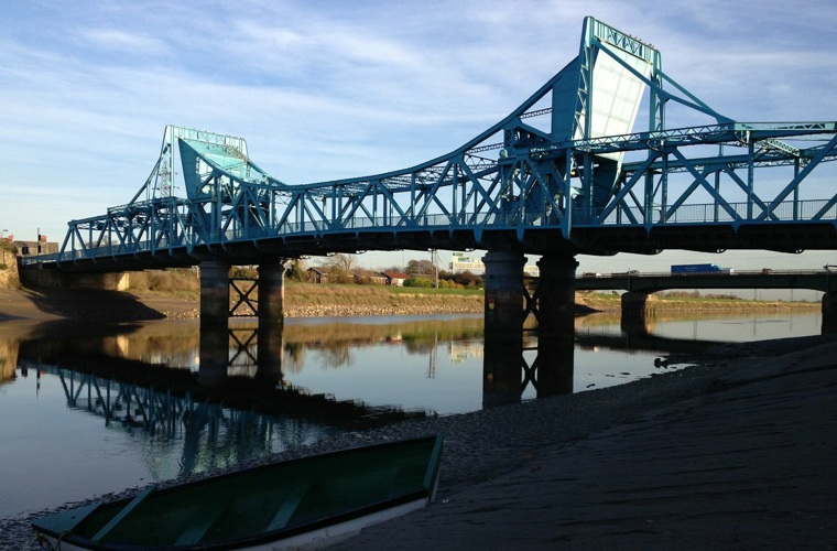
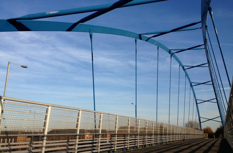
By the early 19th century there were two points where you could cross the River Dee - at Higher Ferry (Ferry Lane) and at Lower Ferry. This was later called Kingsferry but was changed to Queensferry when Queen Victoria came to the throne. As the amount of traffic coming through on the turnpike from the Wirral increased, it became necessary to build a bridge. The first bridge was built to link Garden City with Queensferry and opened by W.C. Gladstone in 1897. This bridge was subsequently replaced by the blue Jubilee Bridge, which is a rolling Bascule bridge completed in 1926. This bridge hasn't been able to move to allow passing shipping since the 1960s.
A footbridge replaced the passenger ferry at Ferry Lane in the 1970s.
A bypass was built through Sealand across the River Dee in 1962.
This video shows the arrival of the new foot bridge finally ending the ancient Saltney Ferry service from Sealand Ferry Lane to Saltney Ferry.
RAF Sealand
RAF Sealand was a major centre for defence and many people will still remember the iconic Spitfire fighter plane on its plinth at the main gates in to the camp. The air base was originally a civilian airfield and was taken over by the military in 1916 for training. Two twin hangars, which were built in 1917, were used by the newly formed Royal Flying Corps. Originally named RFCS Shotwick and later RAF Shotwick, the station was finally named RAF Sealand during World War II.
Immediately pre-war and in the early war years, it was the home of No 5 FTS (Flying Training School), equipped with Airspeed Oxfords. During the war, the Flying Training Schools provided what was in effect intermediate training for pilots who had received initial training and flown solo at an EFTS (Elementary Flying Training School) and who had subsequently been inducted into the RAF. Pilots thus arrived at No. 5 FTS RAF Sealand as APOs (Acting Pilot Officers) and upon satisfactory completion of intermediate training became POs (Pilot Officers), and were prepared for posting to a squadron or OTU (Operational Training Unit). Kenneth Cross spent time at No. 5 FTS as an instructor in the early 1930s. From 5 August 1940, the CFI (Chief Flying Instructor) was Edward Mortlock Donaldson. Amongst the pilots who trained at No 5 FTS, RAF Sealand was Johnnie Johnson.
No. 30 Maintenance Unit RAF was formed there in 1939. Two years later No. 19 Elementary Flying Training School (EFTS) equipped with Tiger Moths was located at RAF Sealand. In 1951 the station was taken over by the United States Air Force. It was handed back to the RAF in 1957.RAF Sealand was originally a civilian airfield and was taken over by the military in 1916 for training. No 30 Maintenance unit was formed there in 1939. In 1951 the station was taken over by the United States Air Force, and then handed back to the RAF in 1957.
The Electronics Business Unit of the Defence Support Group (DSG) occupied part of the original Sealand site since the closure of the RAF station in 2006. The business unit was responsible for the repair and maintenance of Avionic equipment and operates as part of a Trading Fund of the Ministry of Defence. The MOD had contemplated using the site for several purposes, one of the most controversial of which was the idea to turn RAF Sealand into an emergency prison to cope with overcrowded prisons in England and Wales. The complex finally closed
The old Spitfire gate guardian from RAF Sealand - 'TD248' - is now in airworthy condition and is regularly flown at airshows . It is currently operated by the 'Aircraft Restoration Company' at Duxford aerodrome.
Image by Alan Holden
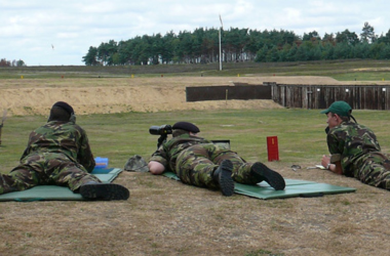
Sealand Rifle Range
Sealand's ranges are still used for shooting, where cadets from the services come to either compete or practice shooting.
Glider Field
No 631 Volunteer Gliding Squadron operated at Sealand between 1963 and 2006, most recently flying the Viking TMk1 conventional winch-launched glider.
Railways in Sealand
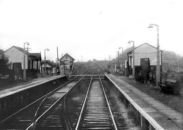
Sealand Railway Station opened on 17th June 1918 and closed on 9th September 1968.
Sealand station was located on the Great Central Railway's (GCR) Chester Northgate to Hawarden Bridge line which opened on 31st March 1890. The line was part of a through route to Wrexham Central and, from 16th March 1896, there was also a line from Hawarden Bridge to Bidston on the Wirral; this was directly accessible from Sealand as there was an east-to-north connecting line a short distance west of the station. By 1905 the entire system between Chester and Wrexham and between Hawarden Bridge and Bidston was in GCR ownership.
Welsh Road goods siding may have opened with the line and it was certainly open by 1899 and comprised two sidings with a cattle pen on the up side of the line. During the Great War (1914 — 1918) a military camp was set up on the north side of the line at Sealand close to a main road between England and Wales: the camp as mentioned above was later developed into RAF Sealand. To serve the camp, Welsh Road Halt — later known as Sealand station — was opened on 17th June 1918. It was only for the use of forces personnel. In May 1919 Welsh Road Halt was opened to the public, and timetabled services began to call there.
Welsh Road Halt was located west of a level crossing just under a quarter of a mile west of the Welsh Road, after which it was originally named. The Chester and Hawarden Bridge line was double-track, so the halt was provided with two platforms. It was initially of timber construction, and each platform had simple single-storey waiting facilities. The platforms were, at some stage, rebuilt in concrete. On the east side of the level crossing was a signal box, located north of the line. It controlled the crossing and the earlier sidings east of the station. Being alongside a military establishment many maps had 'security treatment' and therefore did not show in detail the area around the station.
In 1960 Diesel Multiple Units DMUs were introduced onto the line.
The Reshaping of Britain's Railways (Beeching) report of 1963 recommended the withdrawal of all services from Sealand. However a year later the station still had fourteen weekday services to Wrexham Central, twelve to Shotton High Level, six to New Brighton - trains were diverted there when Seacombe closed at the beginning of 1960 - and thirty-two to Chester Northgate. This was a more intense service than had operated in the 1950s.
Goods facilities were withdrawn on 5th April 1965 although a private siding remained in use. Despite local protest the services between Chester Northgate and New Brighton, and between Chester Northgate and Wrexham, were withdrawn on 9th September 1968, and Sealand Station closed completely. It appears to have been demolished shortly after closure. The private siding remained in use and although the passenger station had been demolished. The goods dock to the east of the crossing were extant in 1985 although the sidings had been lifted.
The line continued in use for goods traffic between Hawarden Bridge Junction and Mickle Trafford until 20th April 1984. On 31st August 1986 the line reopened, again only for goods services. It was reopened as single-track, and at Blacon only the former Chester direction line was retained. The reopening was short-lived, and the line closed again in June 1992. The track was mothballed for a while, but it was lifted before the end of the decade. In 2000 a footpath and cycleway was opened along the course of the line. A station concrete lamp column still survives at Sealand. Since the line between Chester and Dee Marsh closed, the track has been lifted and the route is now a cycle path, forming part of Route 5 of the National Cycle Network.
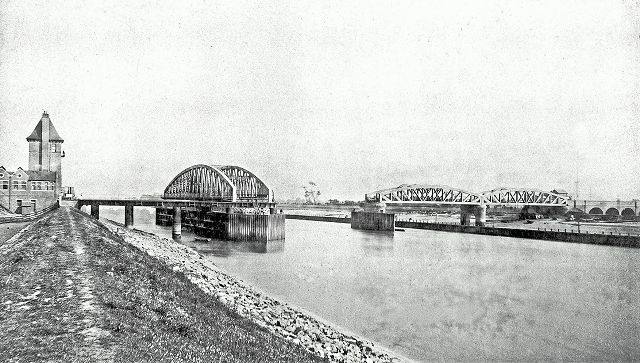
This is a picture from 1889 of the Hawarden Bridge at Sealand shortly after its completion. It is believed the large span was specially swung open for the photographer - the controller can just be seen on a platform on the tower, top left. It was last opened on 29 April 1953, the occasion of the Duke of Edinburgh's visit to the adjacent John Summers Steelworks.
Due to deterioration, the tower was demolished in 1976, the mechanism contained in the bridge removed, and the void filled in with concrete
Origins of Sealand Community Council
Sealand Community Council was originally a Parish council which was were formed under the Local Government Act 1894 to take over local oversight of civic duties in rural towns and villages.
Until 1974 Wales was divided into civil parishes. These were abolished by section 20(6) of the Local Government Act 1972, and replaced by communities by section 27 of the same Act. The Principal areas of Wales are divided entirely into communities. Community councils in Wales introduced on 1st April 1974 and are identical to English parish councils in terms of their powers and the way they operate.